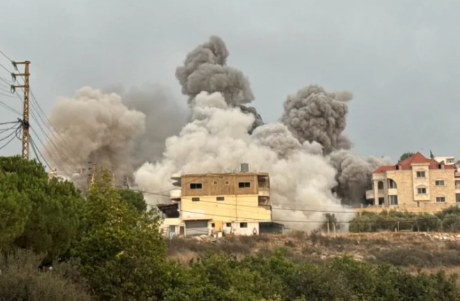

Satellite imagery released this week reveals staggering Asia floods devastation, exposing a continent battered by storm systems that triggered landslides, mass displacement, and catastrophic loss across South and Southeast Asia.
The new images show entire districts submerged, forests erased, and crucial transportation routes severed, forming what one disaster analyst called “a breathtaking but heartbreaking portrait of climate-driven destruction.”
Heavy monsoon rains and powerful tropical systems have ravaged Sri Lanka, Indonesia, Thailand, and Malaysia, killing more than 1,800 people and displacing millions as climate volatility intensifies.
Experts warn these events signal “a regional emergency already in motion,” with governments struggling to respond to collapsing infrastructure, agricultural loss, hunger, and rising public health risks.
The Asian Development Bank’s latest assessment warns that climate-driven water instability threatens billions, revealing vulnerabilities in drainage networks, river defenses, and long-term national planning frameworks.
Indonesia has endured one of its deadliest seasons in decades, with Aceh, North Sumatra, and West Sumatra suffering catastrophic loss magnified by environmental degradation and widespread infrastructure collapse.
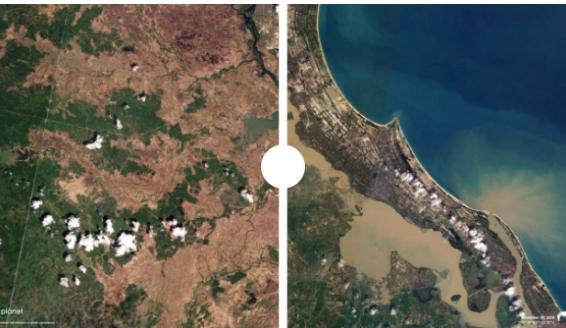
Satellite images expose sweeping destruction across Indonesian coastlines and river valleys, revealing homes swallowed by mud, collapsed bridges, and large swathes of farmland stripped bare.
More than 156,000 homes have been damaged, and officials report shortages of food, medicine, shelter, and vehicles needed to reach isolated communities cut off by rising waters.
Aceh Governor Muzakir Manaf told reporters, “People are not dying from the flood but from starvation,” citing collapsed supply chains and the paralysis of regional road networks.
Remote sensing data also reveals deep scars of deforestation across Sumatra, where illegal logging and palm-oil-driven forest loss have amplified runoff and accelerated deadly landslides.
Environmental scientists warn that “unchecked clearing has erased natural flood buffers,” intensifying mudflows and destroying terrain that once slowed water movement during heavy monsoons.
Indonesian President Prabowo Subianto announced plans to purchase 200 helicopters next year to strengthen disaster response after rescue teams repeatedly failed to reach trapped survivors.
Humanitarian groups argue that while aircraft are necessary, they cannot compensate for structural weaknesses caused by climate change, degraded ecosystems, and decades of underfunded rural development.
Sri Lanka continues to reel from Cyclone Ditwah, the strongest storm to hit the island this century, pushing floodwaters through villages, highways, and critical commercial corridors.
Satellite photos show Colombo’s outskirts transformed into vast inland lakes, reflecting the severity of rainfall funneled into low-lying neighbourhoods already struggling with limited flood infrastructure.
The Disaster Management Centre reports 618 deaths and 209 people missing, with cyclone-driven mudslides leaving entire communities buried and emergency teams racing to recover bodies.
Officials warn that unstable hillsides in the central highlands remain vulnerable, with continued rain pushing soil masses to the brink and heightening fears of secondary landslides.
While water levels are slowly receding, concerns remain high as displaced families crowd into state-run shelters, where shortages and overcrowding risk disease outbreaks.
Aid coordinators say the number of people in refugee camps has dropped from 225,000 earlier this month to about 100,000, yet recovery remains far from assured.
Thailand faces its own crisis, with eight provinces in the central plains, four in the south, and two in the north still under widespread flood conditions.
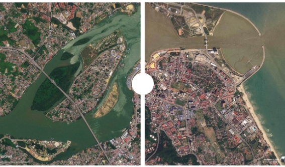
Satellite images show submerged towns and agricultural zones, revealing long ribbons of flooded highways and neighbourhoods where rooftops are barely visible above brown water.
The Department of Disaster Prevention and Mitigation reports 276 deaths, mostly from electrocution and flood-related accidents as residents attempted to navigate dangerous waters.
Volunteers have waded through deep flood zones carrying supplies to stranded communities, describing scenes of “complete silence except for water and the distant sound of collapsing structures.”
Authorities say water levels are receding in several districts, yet many areas remain treacherous, with contaminated groundwater fuelling concerns about sanitation and mosquito-borne illnesses.
In Malaysia, flooding has swept through eight northern states, with satellite images capturing mosques, towns, and farmland partially submerged after days of relentless rainfall.
The National Disaster Management Agency reports at least two deaths, while more than 18,700 people remain displaced across makeshift shelters in schools, halls, and community compounds.

Remote sensing shows rivers overflowing into residential districts, turning entire neighbourhoods into isolated islands surrounded by thick floodwaters that continue to rise unpredictably.
Rescue officials say more than 27,000 people were evacuated last week alone, and forecasters warn more rainfall is expected as unstable weather systems continue swirling across the region.
Malaysia’s humanitarian teams report growing concerns over drinking water contamination, noting that “clean water is becoming as critical as food” in hard-hit states.
Across Asia, satellite imagery illustrates environmental patterns driving destruction, highlighting vulnerable coastlines, eroded hillsides, densely packed cities, and poorly managed drainage landscapes.
Analysts say the visual evidence leaves little room for doubt: climate change is amplifying extreme weather, and insufficient adaptation is deepening the human and economic toll.
Regional governments now face pressure to overhaul flood-mitigation systems, expand evacuation infrastructure, and push for stricter environmental regulation, particularly in high-risk forest zones.
Climate experts are urging collective action, emphasising that “no country can manage these hyper-intense weather events alone,” calling for stronger cross-border coordination and shared early-warning systems.

Satellite data provides an invaluable tool for anticipating future disasters, offering real-time visibility that strengthens planning, resource distribution, and accurate assessments of damaged terrain.
Humanitarian workers on the ground say the images are also vital for identifying hardest-hit rural zones often neglected in traditional disaster-response strategies.
Communities in affected countries face a long and uncertain rebuilding process, with reconstruction costs expected to climb sharply as climate threats continue to intensify.
Many residents interviewed by regional media describe profound trauma, recounting stories of families swept away by landslides or isolated for days without food or medicine.
One survivor from Aceh said, “When the water came, it sounded like the earth was breaking open. Everything disappeared—houses, people, everything.”
As nations assess losses, satellite data will play a central role in mapping priority zones, planning relocations, and developing climate-resilient settlement designs.

Environmental advocates warn that without decisive action, this year’s Asia floods devastation could foreshadow even more catastrophic events in the coming decades.
They argue that the combination of warming seas, severe rainfall, unregulated land use, and dense population growth creates a risk profile “unlike anything the region has previously faced.”
For now, millions remain displaced, grieving, or searching for missing loved ones as weather agencies warn that the monsoon season is not yet over.
Satellite imagery continues to update daily, revealing shifting flood patterns and new destruction, serving both as a tool for relief and a stark reminder of climate vulnerability.
Amid the despair, volunteers and rescue teams persist, delivering food, rescuing the stranded, and offering support in what many describe as the region’s “most challenging humanitarian moment in years.”
Yet even with courage on the ground, experts insist that prevention, adaptation, and ecological restoration must become central pillars of policy if future tragedies are to be reduced.

From the coastlines of Sumatra to the hills of Sri Lanka, the continent now faces a test of resilience, governance, and its ability to confront the accelerating weight of the climate crisis.
Read also: BREAKING: Magnitude 7.6 earthquake strikes Japan, tsunami warnings issued